
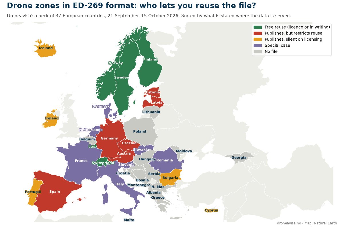
EU rules require every member state to publish its drone zones in one common digital format, ED-269. We checked what is actually online, country by country, and what you are allowed to do with the file. Each entry gives the source and a verbatim quote. This is the English edition of our Norwegian reference page.
What ED-269 is, and why the licence decides
Article 15 of Commission Implementing Regulation (EU) 2019/947 requires member states to define UAS geographical zones and make the information publicly available “in a common unique digital format”. EASA pointed to chapter 8 of the EUROCAE standard ED-269 as that format. In February 2024 EUROCAE moved the data model into a separate technical specification, ED-318, which is meant to cover both geographical zones and U-space. In practice the two formats are near-identical JSON files, and several countries publish both.
The format is only half the job. A file published without terms of use cannot simply be built into a drone app, a planning tool or a manufacturer’s geo-awareness system. At that point it is the licence, not the file format, that decides whether the data actually reaches the pilot. That is why this overview is sorted by what each country says about reuse, not by whether a file exists.
The starting point was a survey by the Italian company Dronetrake, which we covered in a news story on 9 September (in Norwegian). That story had to be corrected twice, and both times the reason was a licence we had not found. Since then we have checked every country ourselves. Everything below is taken from the portal, the file’s metadata, the site’s language files or the national geodata catalogues, and the date of the check is given for each country.
How to read the overview
Each country is placed in one of five groups according to what is stated where the data is served: on the download page, in the file, in the file’s metadata or in the catalogue record for the dataset. General website terms for an authority’s main portal do not count as a data licence, and silence does not count as permission. A written reply from the authority itself counts as a right of use when it grants free use. In that case we quote the reply verbatim and state that it is not a licence.
The groups are about what you may do with the file, in other words reuse, not about whether you can download it. In almost every country that has a file, anyone can download it. The exceptions are Italy, where you have to log in, and France, where the file is free but fetched through a web shop. Both are listed among the special cases.
| Country | File in the common format | Terms of use | Our assessment |
|---|---|---|---|
| Norway | ED-269, ED-318, KML | NLOD 2.0 | Open |
| Luxembourg | ED-269 | CC0 | Open |
| Switzerland | ED-269 (daily) | Opendata BY | Open |
| Sweden | ED-318 (JSON) | CC BY 4.0 | Open |
| Finland | ED-269 | Free use, confirmed in writing (no licence) | Open |
| Germany | ED-269 + WFS/WMS | CC BY-ND 4.0 | Restricted |
| Austria | ED-269 | No right of use granted | Restricted |
| Spain | ED-318 (three files) | Reproduction prohibited without written permission | Restricted |
| Czechia | GeoJSON (legally binding) + ED-318 | Non-commercial, not in other products | Restricted |
| Estonia | GeoJSON in ED-269 schema | App terms only, no data licence | Restricted |
| Latvia | ED-269 (413 zones) | Regulation requires an agreement for commercial use | Restricted |
| Ireland | GeoJSON in ED-269 schema | None | Silent |
| Bulgaria | WFS | None | Silent |
| Cyprus | JSON (May 2025) | None for the data; website “All Rights Reserved” | Silent |
| Portugal | ED-269 (embedded in the map) | None where the data is served | Silent |
| Iceland | GeoJSON via WFS (ED-269-like) | None | Silent |
| Denmark | GeoJSON and others, not ED-318 | “Frit anvendes med kildeangivelse” / “personal use” | Special case |
| Netherlands | Service withdrawn 30 June 2026 | None for the remaining file | Special case |
| Italy | ED-269 behind a login | “Personal use only” | Special case |
| France | ED-269 via SIA (free, shopping basket) | Expressly excluded from Licence Ouverte | Special case |
| Romania | GeoJSON, server rejects modern TLS | Unknown | Special case |
| Slovakia | KML only, not ED-269 | None | Special case |
| Slovenia | KMZ only, not ED-269 | Map: “commercial use not permitted” | Special case |
The basis for each row follows below. Quotes are given in the original language, with our translation where needed.
Five countries grant reuse rights you can build on
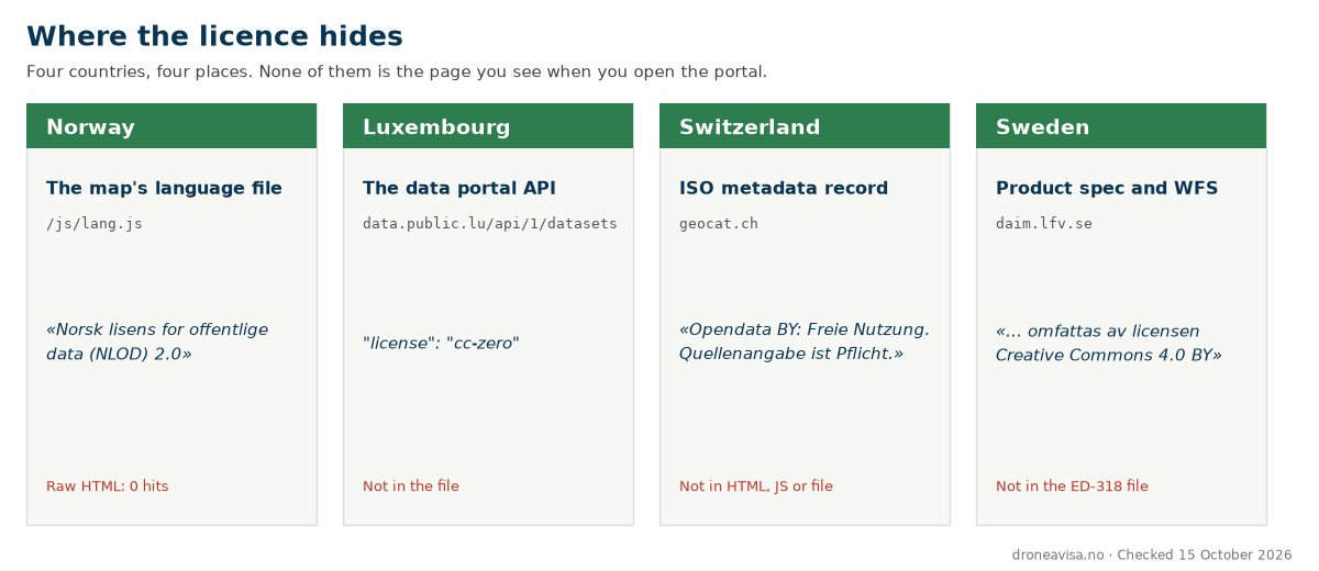
Norway. The Civil Aviation Authority (Luftfartstilsynet) publishes ED-269, ED-318 and KML at dronesoner.no, updated monthly. The licence is the Norwegian Licence for Open Government Data (NLOD) 2.0, and the portal’s own text says that «dataene kan fritt brukes, kopieres, endres og videredistribueres, også i kommersielle produkter og tjenester» (the data may be freely used, copied, modified and redistributed, including in commercial products and services), and that «bruk i tredjepartsapplikasjoner (f.eks. droneapper, planleggingsverktøy) er tillatt» (use in third-party applications such as drone apps and planning tools is permitted). The only obligation is attribution: «Kilde: Luftfartstilsynet / dronesoner.no». The licence text sits in the portal’s language file, not in the raw HTML, so it is invisible to anyone who only reads the server’s response. Checked 22 September 2026.
Luxembourg. The Direction de l’Aviation Civile publishes the dataset “UAS Geographical Zones – Grand Duchy of Luxembourg” on data.public.lu. The catalogue record states "license": "cc-zero", i.e. CC0, last modified 23 July 2026. The licence appears only in the data portal’s API response, not in the file. Checked 22 September 2026.
Switzerland. The Federal Office of Civil Aviation serves an ED-269 file that is updated daily and also contains the three zones in Liechtenstein. The licence is in the ISO metadata on geocat.ch: «Opendata BY: Freie Nutzung. Quellenangabe ist Pflicht.» (free use, attribution mandatory). Neither the HTML, the JavaScript nor the data file mentions it. Checked 22 September 2026.
Sweden. LFV publishes the ED-318 file as a download from Drönarkartan, and the product specification for the map says: «För licensvillkor om hur informationen får användas se följande Creative Commons-licens: https://creativecommons.org/licenses/by/4.0/». LFV’s WFS service says the same in AccessConstraints: «Denna tjänst omfattas av licensen Creative Commons 4.0 BY». Note two things. The UAS layer «tillhandahålls ej som WMS/WFS utan finns att ladda ner från Drönarkartan som JSON (ED318)», so it is the product specification, not the WFS terms, that covers the file. And the licence was CC BY-NC-ND as late as August, according to Dronetrake. We counted Sweden as “no terms” on 21 September because we had only looked in the file and in the map’s JavaScript. Checked 22 September 2026.
Finland. Traficom publishes a complete ED-269 file, 732 zones, downloadable in a single request without registration. The download page, which exists only in Finnish, states a purpose but no licence: the data is offered «koneluettavassa muodossa ulkopuolisille palveluntarjoajille ja ladattaviksi C-merkittyihin drooneihin», that is, to external service providers and for loading into C-marked drones. We asked Traficom directly, and senior inspector Mika Saalasti replied in writing on 23 September: “We have no limitations, nor we have licensing for the use of the ED-269 dataset. You may use dataset freely and distribute dataset to third parties.” The requested attribution is “Source as Traficom”. So there is no licence, but a written confirmation from the authority of free use and redistribution. Dronetrake received the same answer the day before. Traficom points out that the file covers only the geographical zones, not all airspace restrictions, and that it can change daily when temporary zones are created. Checked 23 September 2026.
Six countries publish the file, but restrict reuse
Germany. The DFS platform DIPUL publishes the zones under CC BY-ND 4.0, stated on the download page, in the WFS service’s Fees field and in the Impressum: «Es gelten die Vorgaben der Lizenz «CC BY-ND 4.0» … Die zu nutzende Quellenangabe lautet: dipul, CC-BY-ND 4.0». Redistribution is allowed, including commercially. Derivatives are not, and that hits any tool that reprojects, clips or merges the polygons into a dataset of its own. Checked 22 September 2026.
Austria. Austro Control publishes ED-269 with a version for every change, and the disclaimer on the download page closes the door: «Mit der Bereitstellung … ist weder eine Einräumung/Übertragung derartiger Rechte noch irgendeines anderen Nutzungsrechts … verbunden» (making the data available does not grant or transfer such rights or any other right of use). Checked 21 September 2026.
Spain. ENAIRE publishes three ED-318 files in the AIP. The legal notice says that «cualquier reproducción, transmisión, adaptación … están estrictamente prohibidos salvo autorización previa por escrito de ENAIRE» (any reproduction, transmission or adaptation is strictly prohibited without prior written authorisation from ENAIRE). The dataset is not available under a reuse licence in the national portal datos.gob.es. Checked 22 September 2026.
Czechia. DroneMap publishes zone boundaries as GeoJSON declared legally binding, alongside a generalised ED-318 version. Technically this is among the best data in Europe. The licence terms, which sit only in the map’s Czech language file, say that the user «nesmí obsah digitální mapy DroneMap ani jeho části kopírovat, distribuovat, upravovat, analyzovat či jinak komerčně využívat» (may not copy, distribute, modify, analyse or otherwise commercially exploit the content of the DroneMap digital map or parts of it). Checked 22 September 2026.
Estonia. The file uas.geojson is served from utm.eans.ee with 250 zones in the ED-269 schema. The only thing governing its use is the terms of use for the map application, which say the user has no right to «kopeerida, muuta või kustutada andmeid» (copy, change or delete data). That is an agreement about the app, not a licence for the data. The data page of the transport administration Transpordiamet has no terms, and Estonian law says open data is «üldjuhul», as a general rule, made available for reuse without conditions. The app term is nevertheless the only thing stated where the file is delivered, and we let that decide. Checked 23 September 2026.
Latvia. The air navigation service provider LGS publishes an ED-269 file with 413 zones, updated continuously, from the download page the Latvian AIP refers to. Neither the page nor the file states any terms. The file only says the dataset “is provided by SJSC ‘Latvijas gaisa satiksme’”. The condition is in the government regulation on the zones (MK 248/2024, points 45 and 46): the information is free of charge «ja tā netiek apstrādāta un tālāk izplatīta trešajām personām, lai gūtu komerciālu labumu», that is, as long as it is not processed and passed on to third parties for commercial gain. Commercial use requires an agreement with LGS, which may charge for it. The regulation applies to exactly this data, which is why we count it even though it is not stated where the file is served. Checked 15 October 2026.
Five countries say nothing about licensing
Ireland. The IAA publishes a GeoJSON in the ED-269 schema per AIRAC cycle, 85 zones. The only statement is “REFERENCE ONLY, NOT TO BE USED FOR NAVIGATION!”, which is a disclaimer, not a right of use. The ArcGIS metadata has an empty licenseInfo. Checked 21 September 2026.
Bulgaria. The WFS service responds with empty <ows:Fees/> and <ows:AccessConstraints/>. Dronetrake reports that the download page returns 403 to all of their requests. Checked 21 September 2026.
Cyprus. The civil aviation department publishes a single JSON file, version 6 May 2025, which was more than 16 months old when we checked. No terms for the data. The footer of the website, including on the page where the file is served, says “Copyright UNMANNED AIRCRAFT SYSTEMS (UAS) CYPRUS 2026 – All Rights Reserved”. That is a general reservation for the website, not a term for the data, which is why Cyprus is listed here. It is an interpretation: because the reservation appears on the download page itself, it can also be read as granting no right of use. Checked 23 September 2026.
Portugal. ANAC publishes the zones at dnt.anac.pt, where the ED-269 data is embedded in the map’s JavaScript. Neither the map page, the file nor the guidance states terms of use. ANAC’s general terms apply to «o sítio de internet da ANAC, em www.anac.pt» and do not mention the subdomain. We have asked ANAC and are waiting for a reply. Checked 22 September 2026.
Iceland. The official drone map at kort.gis.is has a download button that delivers the zones as GeoJSON from a WFS service, 220 zones. The fields resemble ED-269 (identifier, restriction, applicability, zoneauthority), but the file does not follow the schema strictly, and the map itself notes that «gögnin eru í þróun», the data is under development. The service’s fees field is empty, and the link in the access constraints field leads to a page that does not exist. We listed Iceland among the countries without a file until 23 September. Checked 23 September 2026.
Seven special cases
Denmark does not publish in the common format. The Danish Civil Aviation and Railway Authority (Trafikstyrelsen) offers GeoJSON, GeoPackage, Shapefile, KML and KMZ without an account, and the download page says ED-318 is a «kommende EU-standard» (upcoming EU standard) that will be available there once it is approved. The standard was published in February 2024. The licence is also stated in two places in two different ways: the English page says “The data below is exclusively for personal use” (last updated 9 April 2025), while the files’ ArcGIS metadata and the Danish download page say «Data kan frit anvendes med kildeangivelse» (the data may be used freely with attribution). The English page also links to older files marked “_old”. Checked 23 September 2026.
The Netherlands withdrew the service. The official PDOK service was withdrawn on 30 June 2026 at the request of LVNL; the endpoints return 404. The file that remains carries its own title, “UASZoneVersion 2025-12-17”, and is now linked from the ministry’s drone page on rijksoverheid.nl. The website is under CC0, but that covers the pages, not the file, and no licence applies to it. Checked 23 September 2026.
Italy publishes behind a login. D-flight has offered downloads in ED-269 format since August 2024, «in accordo con ENAC». The file requires an account, and the site’s terms say the content may not be copied or distributed without written consent, only stored «unicamente per utilizzo personale» (solely for personal use). Checked 22 September 2026.
France publishes, but excludes the file from the open licence. SIA releases «Données zones géographiques UAS» every AIRAC period, free of charge, in ED-269 format, through the web shop’s shopping basket. The page for SIA’s free digital products says everything there is under Licence Ouverte «à l’exception des données des zones géographiques UAS», that is, with the exception of the UAS geographical zones. The Géoportail layer «Restrictions UAS» is published under Licence Ouverte, but that is a different dataset from the ED-269 file. Checked 23 September 2026.
Romania has the data, but the server rejects modern clients. The zones are available as GeoJSON from ROMATSA. Download attempts from an up-to-date Linux machine are rejected before the connection is established: dh key too small. We reproduced the error ourselves. The authority’s own page on geographical zones is behind a bot barrier. Checked 22 September 2026.
Slovakia publishes KML only. The transport authority Dopravný úrad publishes the zones as a single KML file, 273 areas, updated 14 October, without an account. The law requires the authority to make the zones available «v jednotnom jedinečnom digitálnom formáte», in the common unique digital format, but we have found no ED-269 or ED-318 file, either with the authority or in the national data catalogue. Neither the page nor the file says anything about use. Checked 15 October 2026.
Slovenia publishes KMZ only, and the map prohibits commercial use. The civil aviation agency CAA provides the zones as a KMZ file without an account, 137 zones from May 2026, and in a public ArcGIS map. The file does not follow ED-269 and carries no terms. The map’s own text says «Komercialna uporaba posredovanih podatkov ni dovoljena», commercial use of the data is not permitted. Checked 15 October 2026.
Fourteen countries publish no file
Albania, Belgium, Bosnia and Herzegovina, Croatia, Georgia, Greece, Hungary, Lithuania, Malta, Moldova, Montenegro, North Macedonia, Poland and Serbia offer no file for download. We placed Italy among the special cases because the file exists, behind a login. Several of the fourteen deserve a sentence. Hungary writes that the zones “can be downloaded at the bottom of the article”, and at the bottom there is nothing. Belgium and Croatia feed the zones to their map apps without a login, but neither offers a file, and the data is not in the ED-269 schema. Croatia’s map terms also prohibit copying and distribution without written approval. Lithuania has a file in the ED-269 schema that the map app fetches, but it is not offered for download, and the app’s terms say “Commercial use of provided data is strictly prohibited”. Poland, with one of Europe’s most active drone communities, has a map and a flight plan system but no published file, and the 2025 act says that information about the zones beyond name, area and validity is not public information. Greece, Malta and North Macedonia show the zones in maps only. The Greek map serves images, not data, and the aviation authority writes that the zones have not yet been finally adopted. Malta’s map is run by a vendor whose terms of use prohibit use for anything other than one’s own civil purposes. North Macedonia’s map fetches the zones in a format of its own from a service that is not open for download. Checked 23 September and 15 October 2026.
The United Kingdom is outside the EU and not bound by ED-269, but NATS publishes the Flight Restriction Zone dataset in AIXM 5.1 and KML per AIRAC cycle, with direct download and no account. The terms are in the dataset’s metadata, and they pull in different directions: “Not for resale” and “For aviation use only” sit next to “Usage restrictions: Unrestricted”. The UK AIP only says the datasets are “for Aviation Use Only”. Checked 15 October 2026.
What this means for pilots and developers
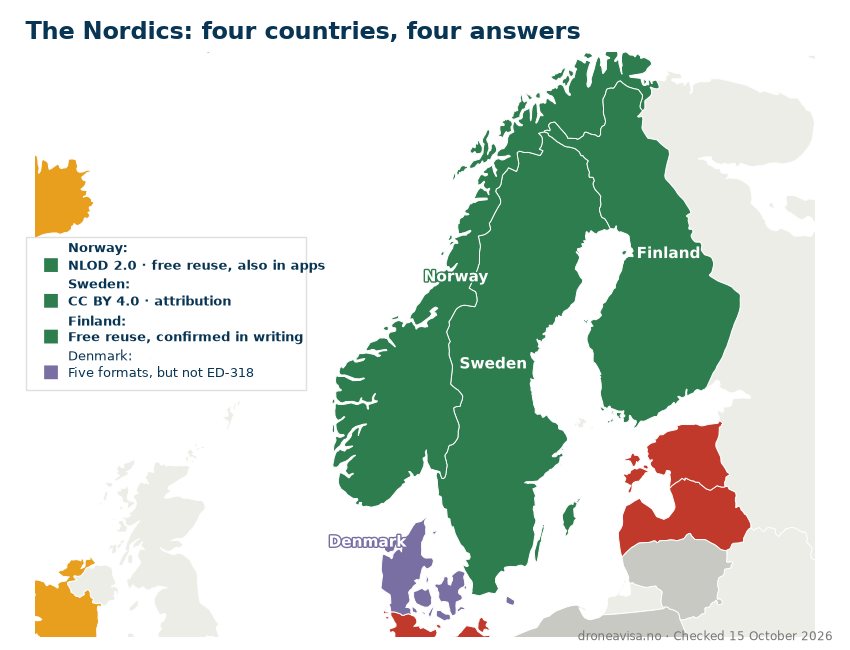
In Norway the picture is simple: the files exist, in the right format, from the right authority, and the licence explicitly says they can be used in drone apps. A developer does not need to ask for permission, only to credit the source.
Across the Nordic countries it is almost as good: Norway and Sweden both provide a licence you can build on, Finland has confirmed free use in writing, and Denmark provides five formats, none of which is the common one. Travel further south and the licence changes at every border. In six of the countries that actually publish, plus Italy and Slovenia, you are not free to reuse what you download.
This is exactly what the common standard was meant to solve: that a drone or an app can read the same file in every country. Seven years after Article 15 was adopted, that holds in five countries.
Fact box: ED-269 and UAS geographical zones
- The rule: Article 15 of Regulation (EU) 2019/947 requires UAS geographical zones to be published “in a common unique digital format”
- The format: EUROCAE ED-269 chapter 8 (data model for geofencing). Carried forward in ED-318 (February 2024), which also covers U-space
- Our count as of 15 October 2026: 37 countries checked, 23 of which have a downloadable file in some form. Five grant rights that allow use in third-party apps: four by licence (Norway, Luxembourg, Switzerland, Sweden) and Finland by written confirmation from Traficom. Six restrict reuse. Five say nothing. Seven are special cases. Fourteen publish no file
- Norway: ED-269, ED-318 and KML at dronesoner.no, 4,341 zones, updated monthly, NLOD 2.0
- Method: Each country was checked by Droneavisa against the portal, the file, the file metadata and the national geodata catalogue. The date of the check is given for each country. Portals change, and AIRAC cycles last 28 days; the overview is updated when we find changes
Changes to the overview
The overview is updated when a country changes its file or terms, or when an authority replies to us. Each change gets one dated line here, newest first.
- 15 October 2026: Six countries missing from the overview were added: Latvia (restricted, because the regulation requires an agreement for commercial use), Slovakia and Slovenia (special cases: a file, but not in the common format) and Greece, Malta and North Macedonia (no file). For the United Kingdom, the terms in the NATS dataset metadata were added.
- 23 September 2026: Iceland moved from “no file” to “silent”: the official drone map has a download button for 220 zones, with no terms. France clarified: SIA expressly excludes the ED-269 file from Licence Ouverte. Estonia, Cyprus, the Netherlands, Denmark and the countries without a file were clarified after a new check of the primary sources.
- 23 September 2026: Finland moved from “silent” to the countries with free reuse rights, following a written reply from Traficom the same day. Traficom has no licence but confirms free use and redistribution. The green group is therefore called “reuse rights” rather than “licence”.
- 22 September 2026: Overview published (in Norwegian). Sweden is counted among the countries with an open licence (CC BY 4.0, stated in LFV’s WFS terms and in the product specification for Drönarkartan). In our first check on 21 September Sweden was listed as having no terms, because we had only looked in the file and in the map’s JavaScript.
Written by Frode Friestad, editor of Droneavisa.no, a Norwegian news site on drones and aviation technology, and an A2-certified drone pilot. The overview is based on Droneavisa’s own checks of each country’s sources on 21–23 September and 15 October 2026, a written reply from Traficom, and the survey by Dronetrake, which we used as a starting point and verified country by country. English edition published November 2026; the Norwegian page is the master version and is updated first.
Sources
- Dronesoner.no (Luftfartstilsynet) – language file with licence text and change log, checked 22 September 2026
- data.public.lu – catalogue record for UAS Geographical Zones – Grand Duchy of Luxembourg
- geocat.ch – ISO metadata for the Swiss ED-269 dataset
- LFV – Drönarkartan product specification and WFS GetCapabilities
- DIPUL (DFS) – Impressum and download page
- Austro Control – download page for Datensatz der geografischen UAS-Gebiete
- ENAIRE – Aviso Legal; datos.gob.es
- DroneMap (Czechia) – language file locales/index.cs.json
- EANS – kasutustingimused (terms of use) for Droonikaart; utm.eans.ee/avm/utm/uas.geojson
- Traficom – UAS-ilmatilavyöhykkeet koneluettavassa muodossa, and written reply from Mika Saalasti to Droneavisa, 23 September 2026
- IAA – UAS zones GeoJSON and ArcGIS metadata
- Department of Civil Aviation Cyprus – Geo Zones JSON File
- ANAC – Portuguese UAS Geozones
- Trafikstyrelsen – Data Downloads (Danish), Data for Download (English) and dronezoner.eu/API
- D-flight – news item 2 August 2024 and Termini e condizioni d’uso
- SIA (DGAC) – Données zones géographiques UAS and Guide d’utilisation v2026-09-11
- EUROCAE – ED-318 – Technical Specification for Geographical Zones and U-Space data provision and exchange (8 February 2024)
- LGS (Latvia) – UAS ģeogrāfiskās zonas, download of the ED-269 file; MK 248/2024, points 45–46
- Dopravný úrad (Slovakia) – Zemepisné oblasti UAS, KML file
- CAA Slovenia – Geografske omejitve za UAS, KMZ file and ArcGIS map
- HCAA (Greece) – Where you are allowed to fly UAS in Greece; the DAGR map and uas.hcaa.gov.gr/Faq
- Transport Malta – Geographical Zones and the map’s terms of use
- CAA North Macedonia – drone.gov.mk, public map
- NATS – Digital datasets, UK UAS Flight Restrictions (metadata), and UK AIP GEN 3.1
- Dronetrake – «A common unique digital format: what actually happens when you try to download it», checked 31 July, revised 21 and 22 September 2026
This article was produced with AI assistance based on the sources above, and published under the editorial responsibility of Frode Friestad, Droneavisa.